Vernagtferner high alpine environmental laboratory
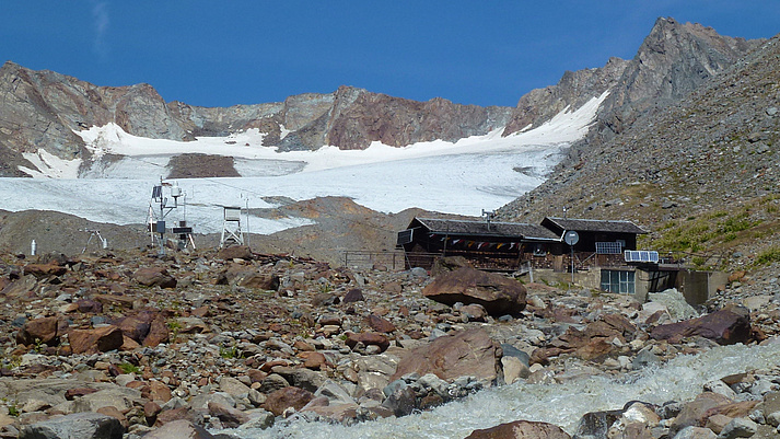
The catchment area of the Vernagtferner gauging station provides an excellent basis for empirical studies on problems of modern glacier research, thanks to the measurement technology installed in the glacier foreland and on the glacier itself. Only a few stations worldwide have comparable prerequisites for precise meteorological, hydrological, geodetic and geophysical measurements in a high alpine environment that is difficult to access, as well as similarly long time series.
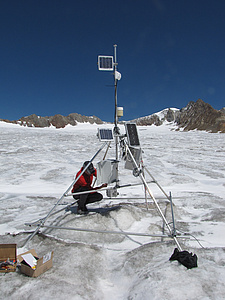
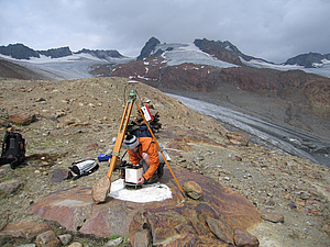
Since 1968, weather data, such as temperature, air pressure, precipitation, wind speed and radiation values, have been continuously recorded, along with, since 1973, the water level of the Vernagtbach stream. On the glacier itself, snowfall (accumulation) and ice melting (ablation) are measured both at individual points (continuously) and at distributed points (at annual intervals). This can be used to determine the mass balance of the glacier, i.e. whether the glacier as a whole is increasing or decreasing. The glacier topography is measured at intervals of 5 to 10 years in order to determine the mass balance by comparing the results with previous measurements. The hydrological measurements of the runoff of the Vernagtbach stream serve the same purpose. The difference between precipitation, evaporation and runoff can be used to determine the change in the water stored in the form of ice in the glacier.
The data collected at the Vernagtferner are made available to the larger scientific community in publicly accessible databases such as PANGAEA, a geoscientific data archive of the Alfred-Wegener-Institut and the Zentrum für Marine Umweltwissenschaften (Centre for Marine Environmental Sciences). The data records archived there for the long term include data on the mass budget of the Vernagtferner, the hydrometeorological data of the Vernagtbach catchment area and all other data on the geometry of the glacier, including historical images.
These data serve as input variables and as a basis for the validation of glacier models, which simulate the mass budget as well as the ice dynamics and runoff of the Vernagtferner and are part of the analyses of global data sets on climate-glacier relationship, for example of the World Glacier Monitoring Service.
In the course of the scientific field work, existing measuring methods and instruments are modernised and combined with new ones. The research at the Vernagtferner enables comparative measurements and the testing of new instruments under real conditions. On this basis, methods and procedures can be developed and thoroughly tested, which are then successfully applied in other glacier regions.
A specific example of this is the gravimetric determination of the mass balance. While the glaciological method (accumulation - ablation) and the hydrological method (precipitation - runoff - evaporation) determine the mass budget only indirectly, the geodetic method actually identifies volumetric and not mass changes from the difference of the glacier topography at different dates. However, the gravimetric method of mass balance determination - the measurement of changes in gravity - is true mass balancing. As a completely independent measurement method, the gravimetric approach is not only suitable for validating the conventional methods of mass balancing, but also provides additional useful information on the development of a glacier, for example on the compaction of snow to ice and on crevasssing, especially by comparing volumetric and mass changes. In combination with ground-based radar measurements or seismic data, gravimetry helps to determine the glacier thickness.